Add contour map functionality
Nobody has claimed this yet.
Assessment
- Difficulty
- 5/5
- Estimated time
- Over a week
- Newbie friendliness
- 20/100
- Issue type
- Feature
- Clarity
- Needs clarification
- Activity status
- Stale
- Tech stack
- python
- Domain
- data-visualization
Research direction
The issue does not name any implementation files, tests, or entry points. Start by reviewing Folium's existing layer and data-visualization APIs to determine whether scattered measurements can support contour maps; done would require a defined API and documented support for this map type.
Written by the indexing model from the issue text.
Description
Dear all
I would like to make a map of weather-like data as temperature or pressure on a folium map similar to the plot below (from https://cdoovision.com/us-temperature-contour-map/):
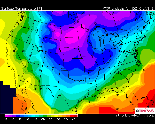
As it can be seen it is not a choropleth map as the contours go through the states and it is not a heatmap as I do not care how many measurements underlies this. The data I have is not gridded, but I have many individual measurements semi-randomly scattered over a large area.
Is this possible in folium currently in any way?
- Dominant language
- Python
- Stars
- 7.4k
- Forks
- 2.3k
- Avg merge
- 17h 22m
- Merged PRs (30d)
- 11
Contributor guide
First steps
- Read the whole issue, then the project's contributing guide.
- Comment on the issue to say you are picking it up — it saves two people doing the same work.
- Fork the repository and make your change on a branch.
- Open a pull request that references the issue number.
More from python-visualization/folium
-
documentation
Difficulty 2/5 1-3 hours Newbie friendliness 68/100
python-visualization/folium#2092 · 5 comments ·
-
Difficulty 3/5 1-2 days Newbie friendliness 67/100
python-visualization/folium#2278 · 1 comment ·
-
Difficulty 5/5 Over a week Newbie friendliness 25/100
python-visualization/folium#2259 ·
-
Map output from OSM returns blocked tiles, due to defective request or not following referer-policy Open
Difficulty 3/5 1-2 days Newbie friendliness 55/100
python-visualization/folium#2236 · 5 comments · 1 reaction ·
-
Difficulty 5/5 Over a week Newbie friendliness 10/100
python-visualization/folium#2219 · 2 comments ·
All issues in python-visualization/folium
Similar issues
-
essnmx good first issue
Difficulty 1/5 Under an hour Newbie friendliness 95/100
-
[Feature] 奇物选择添加优先级 Open
Difficulty 2/5 1-3 hours Newbie friendliness 65/100
syfoud/Simulated_Scepter#174 ·
-
Difficulty 2/5 1-3 hours Newbie friendliness 75/100
Giskard-AI/giskard-oss#2840 · 1 comment ·
-
A claim comment carrying the issue number is silently declined while the workflow reports success Openarea: repo bug perceived difficulty: 2
Difficulty 2/5 1-3 hours Newbie friendliness 70/100
-
Difficulty 2/5 1-3 hours Newbie friendliness 75/100
yeti-platform/yeti#1380 ·